Learn more about the daily distances on the K2 Base Camp Trek. When you are planning your training and preparation for your K2 Base Camp Trek you need to consider three things.
1). How much distance you will be hiking each day. You will need to be training for these types of distances on the trail to K2.
2). Consider the elevation gains will you be hiking each day. If you are hiking up and down hills and trails you need to be factoring these into your training.
3). Factor in the lack of oxygen. Training with a weighted backpack will help give you the physical condition needed for the trek.
Start Training
When you combine these three factors you can build a training plan for your trek to K2. Below are the daily distances you will be hiking along with the distances. We recommend only hikers and trekkers join this trip. This is not a tourist trek. We also recommend that you are training 4/5 times a week building the time and hours you are training over months of training. We also recommend you build up to carrying double the weight you carry on the trail so building from 6kg to 12kg in your training.
After arriving in Islamabad you have to fly to drive to Skardu and onto Askole. After arriving and working your day to Askole on our itinerary you will start trekking on day 5 of our itinerary.
Day 5). Trek to Jhola
Trek to Jhola 3,200m/ 10,500 feet. We set off early to avoid the heat of the day, but the route is gentle and enjoyable. We cross the Biafo Glacier on the way and get our first sight of the Paiyu pinnacles. You will be trekking for 7/8 hours today. The Distance is 21km. Elevation Gain/Loss: 400m/ 500m Min/Max Elevation: 3,045m/ 3,159m
Day 6). Trek to Paiju
Trek to Paiju 3,450m/ 11,319feet. If the river is sufficiently low we will edge our way round the base of the huge rock walls that guard the valley towards the Baltoro glacier. We may have to make the higher traverse before we regain the old riverbed that leads to Paiju. Paiju will be our campsite for the next two nights. Despite the stories in old guidebooks and journals, much has been done in recent years to remove rubbish and human waste. The region is incredibly clean with well managed camps. In fact, they are some of the best we have seen. Daily Distance: 20.5 km Time trekking: 7-8 hours. Elevation Gain/Loss: 575m/ 334m. Min/Max Elevation: 3,115m/ 3,405m
Day 7). Trek to Khoburste
Trek to Khoburste 3,930m/ 12,894 feet. A tough day of walking as we tackle the rocky moraines of the Baltoro Glacier, but the sight of Paiyu Peak and the Trango Towers are truly astounding. Trekking Distance: 14.7 km. Trekking Time: 5-6 hours. Elevation Gain/Loss: 641m/221m. Min/Max Elevation: 3,379m/3,909m.
Day 8). Trek to Urdukas
Trek to Urdukas 4,130m/ 13,550 feet. Today you should get your first distant sight of Broad Peak and the Gasherbrums. The campsite is located on a grassy slope high above the Baltoro and commands one of the most intense mountain views in the world, which is dominated by nameless Tower, claimed to have the tallest granite wall in the world. Trekking Distance: 6.2 km. Trekking Time: 4-5 hours. Elevation Gain/Loss: 249m/39m. Min/Max Elevation: 3,819m/4,130m
Day 9). Trek to Goro
Trek to Goro 4,350m/ 14,271 feet. Now we are in the heart of Concordia with only ice on which to place our tents we are surrounded by views of the great peaks: Muztagh Tower, Gasherbrum 4 and the most spectacular of them all Masherbrum, it’s guaranteed to take your breath away. If we are rewarded with a clear evening, nothing will have prepared you for the evening sunset and the red hue over Masherbrum, it will never be forgotten! 7-9hours Day 12-13 Trek to K2 Base Camp 5050m the mountains had been placed in order for this trek, today the finale would have won an Oscar.
We move up to Concordia passing the Golden Throne and Mitre Peak as we enter the arena of the 8000m Peaks, first Broad Peak 8,047m/ 26,401 feet followed by the Gasherbrums and finally K2. The sheer size and scale of the 8000 meter peaks defies description, but this is a very special place and for many the view is a lifetime goal. Unlike many other treks to this area, ours continues up to K2 base camp where you will stay for a few days to enjoy the sheer majesty of K2 and its supremacy over this whole region. Distance: 12.2 km. Trekking Time: 7-8 hours. Elevation Gain/Loss: 329m/89m. Min/Max Elevation: 4,009m/4,279m
Day 10). Baltoro Glacier, Trek to Concordia 4,500m/ 14,764 feet
Baltoro glacier trek to Concordia offers the greatest spectacles of the Gondogoro La Trek. We continue our walk on the mighty Baltoro while participants pass by Mustagh Tower 7,284m/ 23,897 feet and Gasherbrum IV, partially obscuring behind it the Gasherbrum I 8,080m/ 26,509 feet thus called “Hidden Peak”. We can spot it on the right side of Gasherbrum IV with fin like ridges.
Making our route up on Baltoro, views of Broad Peak 8,051m/ 26,414 feet appear while Marble and Crystal Peaks appear on the left. K2 remains concealed till the minute we reach Concordia; a breathtaking sight that becomes a beautiful memory forever. Concordia is wide area of glacier which is one of the greatest places on earth. We will be surrounded by 4 eight-thousanders, 10 out of 30 highest peaks of the world. Camp will be set at 4,500m/ 14,764 feet in Concordia on the moraine. Trekking Distance: 11.8 km. Trekking Time: 4-5 hours. Elevation Gain/Loss: 289m/3m. Min/Max Elevation: 4,279m/4,570m.
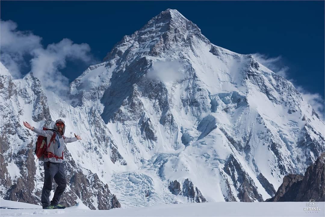
Day 11). K2 Base camp 5,100m/ 16,732 feet and Broad Peak Base camp 4,800m/ 15,748 feet
On this day of Gondogoro La Trek, we can start early through crevasses and small rivers created by melting ice. We follow on the glacier that is named after Godwin Austin who first declared K2’s height. After three hours we will be at Broad Peak base camp where we will have a great sight of the astonishing Karakoram 2nd (K2), Mitre Peak behind us and the Bride Peak. We walk on the moraine which is mostly boulders. However, we do walk on ice occasionally.
After another 3 hours trek, we shall complete one-way journey of the K2 Base Camp reaching a moraine safe zone, a traditional base camp area for K2 climbers. One can also visit Gilkey Memorial if time allows. The memorial has names of brave souls inscribed on plates and plagues. These tough ones died attempting K2. The decisions about trekking to K2 Base Camp, Broad Peak BC, Gilkey Memorial, choosing one or another or all options or choosing to rest at Concordia on this day depends on the participants. Return to Concordia on this day is compulsory. Trekking Time (Return) K2 BC: 9-11 hours. Trekking Time (Return) Broad BC: 5-6 hours. Min/Max Elevation: 4,500m/5,100m.
Day 12). Trek Towards Ali Camp 4,800m/ 15,748 feet
We set out journey on a less explored route today. The nature and difficulty of trekking depends on snow which is not common between the months of June to late August. Normally we would walk on non-slippery ice which is in fact easy to hike on. In case of large crevasses, we would take short detours only to make progress. However in case of snow conditions at Baltoro, participants and porters would walk together (all hooked to a rope) and use their crampons for safety.After walking for more than 5 hours, we should reach the junction point of Baltoro with West Vigne Glacier that is linked to Gondogoro La’s base.
We set camp for tonight on the high moraine near the junction. Our campsite is known as “Ali Camp” as Ali (a porter belonging to nearby village) had first been recorded to cross Gondogoro La while returning as a porter from a climbing expedition to Gasherbrum. Reaching camp, we would have enough time to learn and practice some basic skills for moving on the Gondogoro La Trek’s fixed lines the following day. Trekking Distance: 12.1 km. Trekking Time: 5-6 hours. Elevation Gain/Loss: 376m/13m. Min/Max Elevation: 4,500m/4,800m.
Day 14). Gondogoro La pass
Gondogoro La Trek-Crossing the Gondogro La/Pass 5,585m/18,323 feet towards Khuspang On this day of Gondogoro La Trek, participants are woken up sooner than first light. After a good breakfast, harnesses and crampons are put on and we hit the incredible West Vigne Glacier, all roped as one unit until we make to Gondogoro La’s base. Depending on weather and snow conditions on the lower slope of the high pass, we may possibly continue as one unit attached to the rope or we might be in a position to ascend the slope un-roped.
Normally there would be at least one steep part to cross on the higher slopes. During these parts of the climb, our support crew will fix ropes. It normally takes around three hours to reach the top of Gondogoro La Pass. One can have a splendid view of four of the 8,000 meter peaks, specifically Gasherbrum 1 and 2, Broad Peak and the mighty K2. The giant pass is one broad shoulder from where we get a perfect view of the astonishing Gondogoro valley on the opposite side. While descending down the other sturdy side, one can enjoy views of Trinity peaks, not to mention the stunning Laila Peak 6,096m/ 19,111 feet.
The fall is comparatively sudden and therefore requires use of fixed ropes for most of the descend. Crampons would be required for the most part of moving down the pass and also on the upper segment of Hushey valley which will normally be covered in snow. Participants will need to watch their every step while descending to avoid jolting stones into their team members. Once the gradient eases, we get to a trail moving along the beautiful Gondogoro valley above Trinity Glacier that we meet soon. Gondogoro La Trek eventually becomes easy as we reach and move on the moraine and arrive at a valley with small pools and grass near the junction point of Gondogoro and Trinity glaciers. This pleasant campsite is called Khuispang 4,600m/ 15,091 feet. Trekking Distance: 8.1 km. Trekking Time: 9-12 hours. Elevation Gain/Loss: 798m/901m. Max Elevation (Pass): 5,585m.
Day 15). Walk to Dalsmpa Via Gondogoro Glacier
Today we pursue the Gondogoro glacier downwards and it will comparatively be an easy day on the Gondogoro La Trek. Normally we would pack our climbing equipment’s while descending towards Hushey valley and witness fresh landscapes. Participants trek on Gondogoro glacier’s moraine, walk below and cross Laila Peak. The official first summit on this stunning peak was made by Italian climbers in mid 1990’s only to find evidence of a previous mark on the summit by British mountaineers (Mark Miller, Simon Yates and Sean Smith) in 1987.
The Italians apparently did not know of a previous attempt by the British mountaineers before they found a used gas cartridge with inscriptions of four names. We continue and reach an edge of Gondogoro Glacier and find a trail into a beautiful valley of rhubarb and grass. We set camp at a gorgeous location known as Dalsampa 4,150m/ 13,615 feet. Trekking Distance: 6.1 km. Trekking Time: 4 hours. Elevation Gain/Loss: 102m/548m. Camp Elevation: 4,149m.
Day 16). Trek to Saicho
Trek to Saicho 3,350m/10,990 feet through Gondogoro Valley. We start off trekking through this amazing valley where participants camped last night. The valley soon comes to a sudden end where we are left with two options of trail. The first option is to trek down between cliffs and the glacier. The second option is to move forward on the cliffs. Our guide will make a decision based on discussion with local porters who trek more frequently and are aware of recent conditions on at least one of these routes. Gondogoro La Trek becomes easy once both these trails meet.
We continue trekking and pass through the pastures of Gondogoro. One can see temporary shelters made of stones by herders. Soon a little stream requires to be crossed before reaching the lateral moraine. One can observe big trees while walking on this moraine that goes down until the bottom of Gondogoro valley where camp is setup. Our campsite Saicho 3,350m/ 10,990 feet is a sandy part with thin grasses along the glacial river at junction point of the Charakusa and Gondogoro valleys. After almost one week above 4,000m altitude, “oxygen rich” supply of air will be available to breathe and participants can sleep better to the sound of running water. Trekking Distance: 11.9 km. Trekking Time: 5-6 hours. Elevation Loss: 798m. Camp Elevation: 3,350m.
Day 17). Contingency Day in Case of Possible Delays
There can always be a chance for delays at some point during Gondogoro La Trek. It’s always a good idea to keep time for this. Otherwise normally this day would be used for rest at Saicho which is a good camping site to get some sun bath, fill in your diary or do some laundry. Those who still want to explore can trek to Charakusa valley. If anyone opts for this option, we shall make an early morning start and pursue a trail upstream on moraine (lateral) of Charakusa Glacier, a habitat for snow leopard.
On a lucky day someone from the team may spot an animal or at least see signs of the big cat which our guides can guide you to. After crossing some ice and rubble, moraine and glacier, we make it to major Charakusa glacier. How far to go depends on when we start, glacier conditions and participant’s energy level. Although if every factor is favorable, we can walk far enough to get views of K7 and K6. It will approximately take 6-8 hours to make this round trip which is another great extra on the Gondogoro La Trek.
Day 18). Trek to Hushey’s Main Village, Last Trekking Day
Since we are below 3,500m/ 11,500feet, it is wise to start trekking early to stay away from heat that can go above 35 degree Celsius. This day will comparatively be an easy trekking day of between 3 to 4 hours. We will follow the river that brings the glacier melt of Charakusa, Gondogoro, Ailling and Masherbrum glaciers. The valley eventually turns south and gradually participants start to see signs of shelters, homes, fields etc and we finally ascend to a plateau where the central village is located.
The central village is made of alleys, traditional stone-made buildings built with river stones etc. The buildings are two-storey structures. Ground floors are used to shelter animals whereas the upper floors shelter humans.More recently villagers have also built modern houses. The village has a school, hotel, shop and a camping site for trekkers where our team will make camp. The remaining day can be used to rest or to explore the Hushey village and interact with the community who are tourist friendly and most hospitable. It will be the last day of camping on Gondogoro La Trek. Trekking Distance: 7.2 km. Trekking Time: 3-4 hours. Elevation Loss: 302m. Camping Elevation: 3,050m.
Day 19). Drive to Skardu Following the rivers of Hushey Shyok and the Grand Indus
The return road journey offers amazing sightseeing starting with passage through other villages of Hushey valley displaying small agricultural lands and mountain farming activities as we move downstream. We eventually come to the confluence where Shyok river (flowing from Ladakh) meets Hushey river. We will cross a bridge (suspension) above Shyok river to get to the other end. In the past traditional rafts (made of air-filled goat skins and large sticks) were used to pass the river. The goat skin was later replaced by tubes of tractor tyre in 1980s and this suspension bridge that is used now was built in1990s. After crossing of this bridge, we will find a surfaced road in Khaplu, a large village that has turned into a town.
Khaplu once was a princely state ruled by a Raja (Prince). Few signs of the princely state still exist. Our drive to Skardu from Khaplu becomes smoother and we gain pace on the paved road driving along the Shyok which leads us to the confluence with Indus River that we follow until we reach Skardu. We arrive at one of our partner hotels and get our first warm shower after more than two weeks, followed by a good meal.
Day 20). Fly to Islamabad, Sightseeing During the Afternoon
The drive from hotel to airport is 40 minutes and it’s a metal road. We board the plane for a thrilling flight towards Islamabad. We once again fly by the Nanga Parbat, saying goodbye to the mountains. On arrival in Islamabad airport our vehicle will take us straight to the hotel. We will settle in and have lunch if there isn’t any unusual delay. After a good meal participants can take the day for rest and sightseeing around the city. You can also do some last minute shopping for popular options like artifacts or rugs. In the evening we will be together to enjoy special meal at local restaurant or at our hotel and share experiences of Gondogoro La Trek.
Day 21). Contingency Day for Delays in Flight Schedule
Skardu is weather dependent area to fly as planes only operate when there is visibility for the pilot to land. The weather in summer is mostly good for the pilots to fly but mountain weather conditions may change to bring rain. Alternative way is to go by road through the Karakorum Highway which is a great experience for many foreigners. If we fly to Islamabad, the day can be used to rest and for sightseeing. The leaders of the trekking party will guide participants on this day with available options.
Day 22). Departure from Islamabad, Airport Transfer from Hotel
Finally, our land package for K2 Base Camp and Gondogoro La Trek ends only with breakfast and transfer to airport. Follow us on Instagram.
If you would like to sign up to one of our premium treks to K2 Base Camp then get in touch. CONTACT US and learn more about this exciting trekking adventure.