Check out our daily distances and elevation gains for our Mera Peak Expedition. Our Mera Peak itinerary is one that takes you off the beaten path, with stunning views and experiences along the way! There are a number of routes into Khare, at 4,950m/ 16,240 feet, which is the last village before moving higher on Mera Peak. Our itinerary takes you on a longer route in to Khare, giving you the best acclimatization as well as a more unique experience, staying in some of the lesser known villages in the region.
All the research on high altitude says to spend more time in the lower part of high altitude, around 3,500m/ 11,500 feet, before going higher. The following is the daily distance on our unique Mera Peak itinerary. This should help you to formulate an appropriate training plan to make sure that you come on the adventure with the RIGHT training and preparations.
Daily Distances on Route to Mera Peak
In our itinerary we have three nights in Khare for additional acclimatization. Also, we always use Mera Peak Base Camp, at 5,350m/ 17,552 feet. This aids in the safety and success of our trips. We have developed the best itinerary for the trek into Mera Peak so you can enjoy more of the Himalaya’s on route to Mera Peak.
We have run over 60 Expeditions to Mera Peak over the last decade. So why not Join our Award Winning Team on our unique itinerary. If you would like further information about our trips and training advice get in touch today.
Day 1). Fly to Lukla and Hike to Poyan
You will be up early for the exciting flight to Lukla 2,850m/ 9350ft. Fingers crossed the weather is in our favor. This is a 45 minute flight from Kathmandu to the small town of Lukla and also the gateway to the Everest region. We will aim to have breakfast in Lukla before starting out on the trek south away from Everest to Poyan 2,800m/ 9,186 feet. The initial part of the trek is down hill for 600m/ 1,968 feet past Surku and then slowly back up 550m/ 1,804 feet to Poyan. The distance is 6.2 miles/ 10km. This is a 5/6 hour hike.
Day 2). Poyan to Pangkongma
From Poyan, we will follow the normal trade route south for a while and then turn east off this trail onto a less traveled trail as we hike steeply up to 3,100m/ 10,170 feet on a narrow ancient stone stair case and then top out passing a random local home. From here we traverse around the side of the hill on a stunning trail and drop down into Khare Khola before turning east and gradually up hill to the town of Pangkongma 2,846m/9,337ft We will stay in a lodge run by a local Sherpa family. We might be lucky enough to be invited into some of the locals homes and see how the locals live in these Himalayan foot hills. The distances is 6.5 miles/ 10.4km. This is a 6/7 hour hike.
Day 3). Pangkongma to Nashing Dingma
We will be up at 6am, breakfast at 7am and start hiking at 8am. As we walk out of town, we will take a stroll up to the monastery, which has recently been rebuilt. After that through the Rhododendron forest on a steep winding stairs up to the Pangkongma la 3,174m/ 10,413 feet. Next, we will follow the ridge line on a long descent down over 1,000m/ 3,281 feet to our lunch spot beside the Hinku Khola river. We will then climb up 600m/ 1,969 feet to the stunning campsite of Nashing Dingma at 2,600m/ 8,530 feet. The distance is 4.5m/ 7.2km. This is a 5/6 hour hike.
Day 4). Nashing Dingma to Chalem Kharka
We will be up again early at 7am and start hiking gradually up through beautiful green fields before a steep stair case up before topping out on the Surka La. As we reach the top, there will be a couple of lodges selling snacks. We cut around the back of the lodge through a forest, fir trees and rhododendron trees. We then move onto a rocky path and back up on rocky stairs to a wide open camp site with a new lodge that we use at Chalem Kharka 3,600m/ 11,811 feet. Distance is 5.6m/ 9km. This a 5/6 hour hike.
Day 5). Chalem Kharka to Chunbu Kharka
The day starts with a long ascent 900m/ 2,953 feet up hill to our high point of 4,500m/ 14,764 feet. We walk out the back of our campsite on a gradual slope and we emerge out into a rocky and baron landscape. This beautiful hike also sometimes has snow scattered across the hills as we make our way to Chunbu Kharka. After an initial 45 minutes uphill section, you will then see the rocky stair case up ahead. We will take a break before this long grind up for a few hours.
We will stop at the top for lunch and it can be cold so make sure you have your down jacket and fleece layer. After lunch the terrain descends gradually over rugged, rocky terrain. If there are no clouds, then you will be treated to some excellent mountain viewing, passing by a couple of lakes. You can take your time in this section of the trail before dropping down into a serene mountain valley where we will camp at Chunbu Kharka 4,200m/ 13,779 feet. Distance is 5.2m/ 8.3km. This is a 6 hour hike.
Day 6). Chunbu Kharka to Khote
Today we will descend down into the village of Khote 3,600m/ 11,811 feet. After 20 minutes of up hill walking we then get great views looking back from the Panch Pokhari view point. From here, we contour around the hill side and then steeply down high above the Hinku valley. The trail follows a rocky path down hill 750m/ 2,460 feet.
We will have lunch in the forest and continue further down to the rivers edge. Turn right or north, cutting in and out of the forest up and down before coming to a small wooden bridge which takes 45 minutes. Cross the bridge and then you have arrived in Khote. This a beautiful setting and one to be remembered. Distance is 4.8m/ 7.2km. This is a 6 hour hike.
Day 7). Khote to Tangnag
After a good nights sleep we have a nice trek to Tangnag 4,360m/ 14,304 feet. The first hour is a beautiful walk with giant mountains in all directions. We then stay on the left hand side of the river, watching out for rock fall on our left. The trail and terrain is gradual mixed rock and pastures where yaks graze in the summer months. Tangnag is growing all the time and we will either camp or stay in a lodge in this beautiful mountain setting. You can sit in a lodge and warm up with a nice fire in the evening. There also maybe an opportunity to do some technical training at the very least you can get your harness set up and practice some knots. Distance is 5.2m/ 8.3km. This is a 4/5 hour hike.
Day 8). Tangnag to Khare
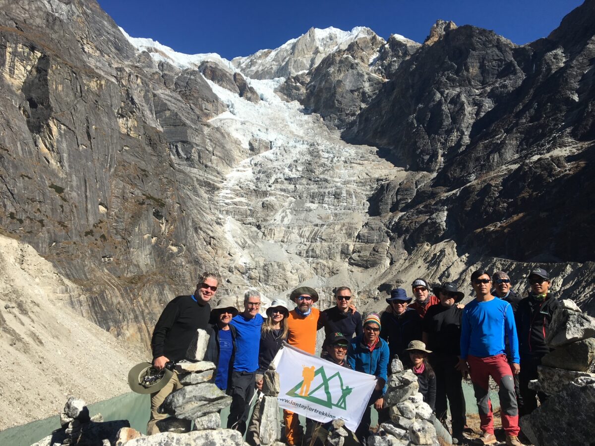
The team will move to Khare 4,950m/ 16,240 feet. The route turns to the east as we trek through the valley floor and then slowly make our way past stunning high altitude peaks. Black Mera is a spectacular mountain rising right out of the valley and we also pass amazing lakes, glaciers, in one of the great Himalayan valleys. We will hopefully arrive in Khare after lunch and relax for the rest of the day. Distance is 3.3m/ 5.3km. This is a 4 hour hike.
Day 9). Technical Training in Khare
We will spend the day in Khare 4,950m/ 16,240 feet. The goal today will be do some technical training needed in preparation for moving higher on the mountain. Moving on a rope as a team is the most important part of moving on the glacier. You can also practicing using a Jumar, figure of 8 and learning how to abseil or rappel and learn as much as you can while you are on this trip.
Day 10). Acclimatization Hike above Khare
Today is another acclimatization day. Our goal is to trek up to 5,350m/ 17,552 feet. There on a stunning hill just above the Mera Peak glacier giving amazing views across Mera Peak and back down the valley towards Tangnag. This will also give everyone a chance to view into a beautiful glaciated valley to the north and be inspired by the sheer size of Mera Peak and the glacier that rolls off the mountain. Khare is developing fast and has some nice lodges to relax and enjoy a warm fire.
Distance is 2.6m/ 4.1km. This will be a 3-4 hour hike, also with time spent hanging our at the high point to give optimum acclimatization.
Day 11). Khare to Mera Peak Base Camp
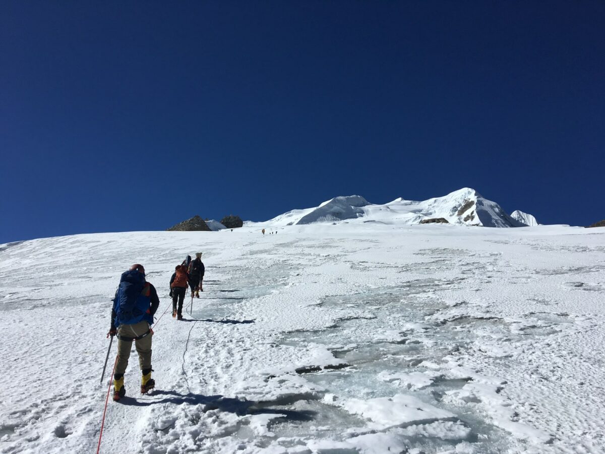
Today we will make the move from Khare to Mera Base Camp 5,350m/ 17,552 feet, as we climb up to the Mera La 5,400m/ 17,717 feet. We will climb up to the Mera Glacier. At first it is easy but the trek up to the glacier is steep in sections and you will need to pace yourself and make sure you are getting your foot placements correctly. There is a chance of rock fall so wearing helmets, crampons is needed. The walk across the glacier is outstanding, with views and memories you will never forget. The descent from the glacier to the campsite is short. We walk between the moraine and the glacier on the northern side as it descends from the col down to the campsite which you can easily see from the glacier. Distance 2.9m/ 4.6km. This takes 3 to 3 hours 30 minutes.
Day 12). Acclimatization in Mera Peak Base Camp
This day is designed to give you some additional acclimatization. There is also an option to doing some additional training on the side of the glacier. You can also enjoy this unique setting as the sun rises you get some great views across the Himalaya’s from Mera Peak Base Camp. Our staff may need to move equipment to high camp. The team may need to move to high camp if the weather is not favorable over the coming days.
Day 13). Move to Mera Peak High Camp
This is it, time to move slowly towards Mera Peak High Camp 5,800m/ 19,029 feet. Climbing back onto the glacier to where we dropped off yesterday and then follow the easy graded snow slopes. After a short distance, we arrive at an area of crevasses which we will have to navigate carefully. We then make are way slowly up to High camp. Remember to look behind you where you will see views of Everest, Makalu, Nuptse and Lhotse. This trek up to High Camp holds some Himalayan treasures. High camp is hidden behind a rocky section and there is not that much space available. The camp site is small and also has some drop offs on the right as you enter the camp. It is time to re-hydrate and recover for the summit push. Distance 1m/ 1.6km and takes about 2 hours 30 minutes.
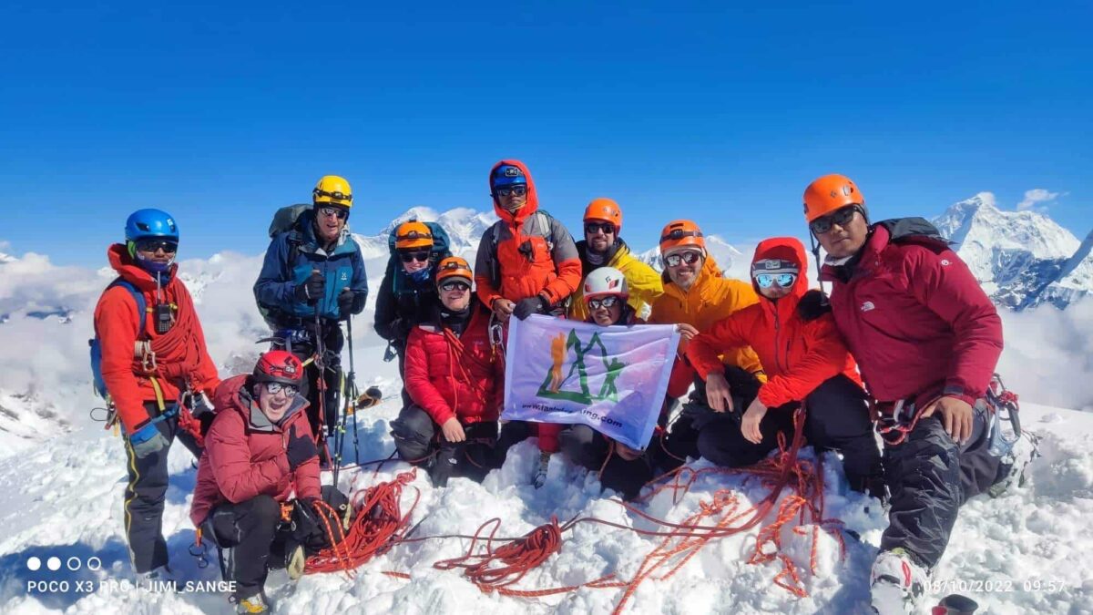
Day 14). Mera Peak Summit Day
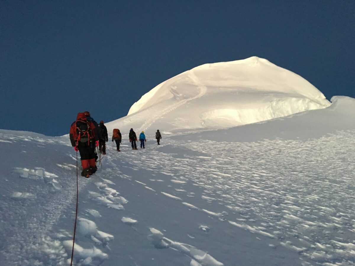
The climb to the summit of Mera Peak starts gradually, and much depends on weather conditions. Firstly, we leave high camp usually at 2am it should take 5/6 hours to reach the summit. Secondly, it is important to get into the rest step on steeper terrain. Taking our time will be critical to conserving energy for the decent. As we come to the end of the steep terrain, the central summit appears above the wide glacier, flanked by 2 ridges. We climb the snowfields avoiding the crevasses. This steep section can take 2 hours and is slow going. The route swings to the east of the left hand ridge before turning back towards the main summit ridge of Mera.
Mera has 3 summits, our objective is the highest. This short steep snow slope is easily climbed. Depending on the year, the final climb to the summit may require you to make a short climb. The last 30m/ 98 feet can require a lot of effort, Jumaring on a short steep snow section and you arrive on the summit.
Finally, after reaching the summit and enjoying amazing views over the Himalayas, we may have a short abseil. We then make the long descent back to High camp. We will rest for one hour before descending back down to Khare at 4,950m/ 16,240 feet. Distance 5m/ 8km round trip. This will take 7/8 hours. The Distance from High camp back to khare is 1.9m/ 3km and take 2 hour 30 minutes to 3 hours.
Day 15). Khare to Khote
After a good nights sleep we will get up early and make our way back to Khote 3,600m/ 11,811 feet. This is one of my favorite hikes all the way into khote. It will take two hours to retract your steps to Tangnag 4,360m/ 14,304 feet and then another 3 hours back to Khote. Distance 8.4m/ 13.5km and takes 5 hours.
Day 15). Khote to Chhatrabuk
We now take a shorter and different route back to Lukla. From Khote it is all uphill to the Zatrwa La pass at 4,620m/ 15,157 feet. Before we cross the high camp we break up the distance and stay in Chhatrabuk. Crossing some ridges helps us on our way to Chhatrabuk 4,300m/ 14,107 feet. Distance 3.4m/ 5.5km and will take 4/5 hours
Day 16). Chhatrabuk to Chhutanga
Today be move from Chhatrabuk to Chhutanga. This is another long day hiking as we move closer to getting back to Lukla. If the team are feeling strong, then it is possible to make it all the way back to Lukla. Chhutanga is not the nicest place to stay. Distance 4.2m/ 6.7km. Hiking 6/7 hours today.
Day 17). Chhutanga to Lukla
This is the easiest and shortest day of the trek. It takes about 3 hours to descend from Chhutanga back into Lukla through the forest. There is one final bridge crossing before the final hike back into Lukla. Once you reach the Lukla Airport you have completed this amazing Mera Peak circuit. You can relax for the rest of the day, before our flight back to Kathmandu early the next day. Distance 2.8m/ 4.5km
Day 18). Fly Back to Kathmandu
You will get up early for breakfast and move to the Lukla airport. Weather permitting you will fly back to Kathmandu and arrive back at the hotel by 9am.
We are Available to Help
Remember when it comes to training for this trip, distances are not the most important reference point. Elevation gains up and down, along with lack of oxygen, should be your biggest considering when preparing your training plan.
Feel free to CONTACT US, we are happy to chat with you about how you should be training for this exciting adventure to climb Mera Peak. Read some REVIEWS from our trips and we look forward to hearing from you.